The service in depth
In water projects, surveying is not a formality — it is the foundation. An easement plan with one badly tied vertex gets rejected; a georeferenced source that doesn't match MINAE's SINIGIR registry stalls the concession; a pipeline staked without control ends up outside the right of way. Spatial precision is what keeps case files moving.
RAM surveys with precision GNSS (RTK/PPK), processes in Civil 3D and QGIS, and validates every product against the national cadastre and institutional registries. The approach is always purpose-driven: we don't deliver “points,” we deliver the exact input the process needs — the easement plan AyA approves, the source georeferencing SINIGIR accepts, the stakeout that keeps the works on their alignment.
This capacity is in-house and cross-cutting: the same equipment and procedures we use on our own works are available as a standalone service for developers, surveyors, attorneys, and ASADAS that need precision with hydraulic judgment.
The problem
A poorly georeferenced hydraulic project gets stuck: rejected easement plans, sources that don't match SINIGIR, cadastral overlaps and works that aren't received. Survey precision is the foundation of every filing before AyA, MINAE and the National Registry.
How we do it
- Survey planning and control points
- Field work with GNSS equipment
- Data processing and validation
- Delivery of georeferenced plans and products
Proven experience
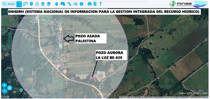
Precision GNSS survey of the Aurora La Luz BE-639 well (ASADA Palestina) validated against SINIGIR, plus the ~10 km network survey for ASADA Juanilama and staking on line-extension projects in Quepos, Esparza and Guanacaste.
Projects behind this service
Aurora La Luz well BE-639
Precision GNSS survey of the ASADA Palestina well, validated against the SINIGIR registry — the kind of georeferencing that decides whether a source file advances or bounces back.
View project →ASADA Juanilama network
Georeferenced survey of some ten kilometers of distribution network as the basis of the ASADA's comprehensive technical study: pipes, valves, tanks, and sources in a single spatial model.
View project →Construction stakeouts
Survey control and stakeout of the pipelines RAM has built — from Big Door Prize to GranSol — keeping every pipe on its alignment and every work inside its easement.
Technologies & methods: GNSS RTK/PPK · Civil 3D · QGIS
Applicable Costa Rican regulations
- Normativa del Registro Inmobiliario y Catastro Nacional
- Requisitos de georreferenciación de la Dirección de Aguas (SINIGIR/MINAE)
- Requisitos base del plano de servidumbre a favor de AyA
Regulatory references are informational and current as of July 2026. Each project and file requires its own technical assessment. Technical lead: Eng. Ariel Fernando Araya Ly · CFIA IC-34246.
Official texts: AyA · Dirección de Aguas · MINAE · CFIA
Frequently asked questions
Do you survey for easements in favor of AyA?
Yes. We produce the survey inputs for easement plans and validate them against cadastre and AyA requirements.
Do you work with outside surveyors or handle everything in-house?
Both. We have our own GNSS capacity and also coordinate with licensed surveyors and notaries when the final product is registral (easement plans, cadastre). What we always contribute is hydraulic judgment over the spatial data.
I have an old plan that doesn't match reality. Can you fix it?
Yes, a typical case: we survey the real situation, identify the conflict (overlap, shift, wrong vertex), and produce the input for the correction — as in the topographic correction file we resolved before AyA at El Salto.
The difference between a file that advances and one that bounces is often measured in centimeters. If your project depends on a plan, a source, or an alignment, secure the spatial foundation with a team that also understands the process.
Related projects
 BE-639 Aurora La Luz well
Aurora La Luz Source Registration — ASADA Palestina
The project had to demonstrate, technically and documentarily, the existence, location, physical condition and validity of the sup…
View full case → ~10 km network surveyed
ASADA Juanilama Technical Study
The ASADA needed to determine the real capacity of its supply system and meet AyA's technical requirements to support future water…
View full case →